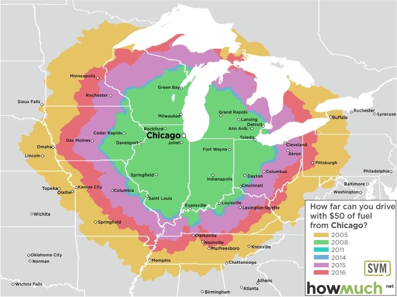
Pack your bags, fill up your tank and go on that Great American Road Trip now: gas prices haven't been this low since 2008! As these maps show, a $50 tank of gas will get you much further on America's highways and byways than at any time since the start of the Great Recession.
These 20 maps, each centered on a great American city, are as many time travel maps. Using historical data from the June months of 2005, 2008, 2011 and 2014 through 2016, they indicate how far that $50 tank of gas would get you – assuming your car's fuel efficiency is 24 miles per gallon (the new-car average for 2014).


 For each of the maps, the outer ring (in yellow) represents your maximum range, based on June 2005 prices. The inner ring (in green) reflects peak prices at the high point of the economic crisis back in June 2008, and thus your minimum range. The difference in distance is considerable. Take a look at these maps, and let you mind's eye travel back and forth in time.
Let's start with New York. So you want to get the heck out of the Big Apple and you have $50 of gas money to burn? Just be glad it's not 2008 any longer. That tank of gas would have only gotten you as far as Biddeford, on the southern tip of Maine, or Cape Charles, near the southern tip of the Delmarva peninsula, both just over 300 miles from the center of Manhattan. That means you wouldn't even have made it as far inland as Pittsburgh, about 370 miles from Times Square. But this year, gas prices are low enough to get as far east as Columbus, 530 miles inland. Mind you, back in 2005, even lower prices got you all the way to Toledo, on the Ohio-Michigan border, fully 560 miles from NYC. For comparable prices and ranges on the eastern seaboard, see Boston and Philadelphia.


Back in June 2005, the average gas price across those 20 cities was $2.22 per gallon. By June 2008, that price had nearly doubled, to $4.15 per gallon. Three years later in 2011, the average gas price had softened to $3.79 per gallon, only to tick up again to $3.83 in 2014. A year later, almost a dollar had come off, to $2.97, and by June this year, the average had gone down by almost half a dollar more, to $2.56 per gallon. But gas prices don't just vary over time, but also per location. Houston consistently is the cheapest place to fill up your car, from a low of $2.07 in 2005 to a high of $3.93 in 2008. The average price per gallon in Houston in June of this year was $2.12.
Meaning that even back in expensive '08, fifty bucks in the tank got you as far as New Orleans, 350 miles to the east. And earlier, in cheap '05, you would get an additional 280 miles out of the same amount, getting you all the way up to Wichita, 630 miles to the north. This year, your road trip out of Houston will get you almost as far. To Amarillo, for example, 600 miles to the northwest, but still firmly in the great state of Texas. Similar prices and distances, see other Texan big cities like San Antonio, Dallas and Austin.


On the other side of the price spectrum, the three major cities in California between them have a quasi monopoly on the highest gas prices: $2.44 in San Francisco in 2005, $4.54 in LA and San Diego in 2008 and $2.97 again in San Francisco last June. At those prices, from Los Angeles you'd only just make it to Las Vegas, covering a distance of no more than 270 miles. Not the worst place to run out of gas. But: no detouring through the Mojave Desert, or you might never make it to the dazzling lights and dancing fountains of the Strip! Even in the cheapest year, a $50 tank of gas would only get you just east of Tucson, which is 515 miles from downtown LA. This year, you won't even make it that far; Phoenix will have to do – but with some gas to spare to explore the Valley of the Sun.

Leaving from Phoenix, your options are not limited by the Pacific Ocean. Even though, back in 2008, you'd run out of gas just before you hit LA, three years earlier you would have been able to drive as far as Clovis and Fresno, or the southern tip of the Mexican state of Sonora. WIth this year's slightly diminished range, you still have the choice of anywhere between Santa Maria, on the Californian coast, and the other side of the Sandia Mountains, east of Albuquerque.


Of course, how far you can get on fifty bucks in the tank is not just a factor of the fluctuating price of fuel, but also of the immutable fact of geography. New York and Los Angeles are port cities, hemmed in on one side by their respective oceans. Landlocked towns have to make do without the soothing sounds of surf beating against the shore, but they have a full circle of land-based destinations to choose from. And those fluctuating fuel prices have a correspondingly large effect on the range. Take Kansas City, the metropolis closest to the nation's geographic center (about 250 miles to the west, in Lebanon, KS). In 2008, you would only get as far as Springfield, the capital of Illinois, just over 300 miles east. The same distance in westerly direction puts you somewhere two-thirds of the way to the Kansas-Colorado border. Three years earlier, you would have made it as far east as Dayton, Ohio – 600 miles from Kansas City. That difference doubles the range, but more than triples the area you can get to on that $50 tank – from just under 283,000 sq. mi in 2008 to 1.13 million sq. mi in 2005. Other cities in the landlocked category include Denver, Chicago, Indianapolis and Columbus.


Arguably, Miami has the worst road trip options in the country - whatever the price of gas. Hemmed in by the Florida peninsula, there is only one way to go: north. Granted, many of the locations you leave behind while travelling in that direction are destinations millions of others each year drive and fly a much longer way to get to, like Tampa and Orlando, just within range of a 2008 tank of gas. In marked contrast, the 2005 price for gas gets you as far as halfway between Savannah and Charleston. Or, if you go the other direction, Florida's state capital Tallahassee.
The options are a bit better on the other side of the country. From Seattle, you could spend that $50 towards a road trip to Canada, exploring all of Victoria Island, a good chunk of southern British Columbia and even skirt the western edge of Alberta - the only time that $50 gets you to a province named after a daughter of Queen Victoria. If you're road-tripping from Seattle, you'd better love the outdoors, because even in southerly direction, that's almost all you'll get to see. That tank of gas covers most of Oregon, a third of Idaho and bits of Montana and northern California. Portland, Boise and Spokane, the three biggest cities in that area, barely share a million inhabitants between them.


For a more varied range of options, leave from Atlanta - or the other hub airport in the region, Charlotte: even at the worst gas prices, back in 2008, you could still reach 7 other states from the capital of Georgia (and 6 from North Carolina's largest city). This year, from Charlotte you'll get as far as Gainesville, Florida; Clarksville, Tennessee; and Louisville, Kentucky. And from Atlanta, you have your pick between Tampa, New Orleans and Indianapolis.
So what are you waiting for? Pack your bags and get thee to a gas station now!
These maps have been created with the collaboration of SVM, the leader in gasoline and retail gift cards.
The $50 American Road Trip - Then and now: 2005-2016 pic.twitter.com/n5E8A2pod8 https://t.co/yn78wfd0yA #usa #dataviz #travel
— How Much (@howmuch_net) August 18, 2016
Please feel free to leave your comments below! We would like to hear your feedback.
Sources & Calculations: Driving Costs Calculations
About the article
Authors
Irena - Editor


